Hiking Iron Goat Trail

The Iron Goat Trail showcases some of the rich history that surrounds Stevens Pass, in the Washington Cascades.

iron goat trail hike Washington railroad tunnel

I have to admit, I am a sucker for exploring ruins or abandoned buildings. There’s something about imagining the life that used to exist around these structures that just draws me in.

So any trail that involves any sort of abandoned houses, castles, forts, or in this  case railroad tunnels, is right up my alley.

History behind the Iron Goat Trail

The Great Northern Railroad was constructed through Stevens Pass in 1893. It was an engineering marvel at the time, crossing mountains passes that were usually impassable during the winter.

There is a “ghost town” at Wellington, the site where a train full of people was swept down the side of the mountain during an avalanche. I did not have time to check it out, but supposedly there’s not much left of the settlement.

The Iron Goat Trail was constructed at a section of the railroad that was bypassed when a new tunnel was built. That tunnel is still used today and you can hear trains passing through occasionally.

The trail passes by old snow sheds and tunnels that were constructed to prevent avalanches from wiping away the trains and the tracks. Part of the trail is paved and wheelchair/stroller accessible.

The Interpretive Site is located in the center of the trail, which forms a loop. There are restrooms and information about the history of the area.

iron goat trail hike Washington railroad tunnel
Information about the history of the Iron Goat Trail is posted at the Interpretive Center.

You can also park at the location where Wellington once sat, or take a forest road to the other end of the trail.

Hiking the Iron Goat Trail to Windy Point

I started my hike from the Iron Goat Trail Interpretive Site. There is a map of the trails on the official website.

iron goat trail hike Washington railroad tunnel
There’s even an old railroad car at the Iron Goat Trail Interpretive Site!

There is about 9 miles of total trail along the old railroad grade. The map denotes the sections where you can see the old tunnels, snowshoes, and other points of interest.

I originally intended to hike a couple of easy miles after my previous hike to Beckler Peak. For some reason I though it would be a good idea to climb even more, to the Windy Point lookout.

Looking at the map, it looked like a short, albeit steep, connector trail. Upon examining the map more closely I realized it was about a mile up to the viewpoint.

While it was more than I was really up for at the time, the climb wasn’t too awful. It’s about 700 feet of switchbacks up the hill.

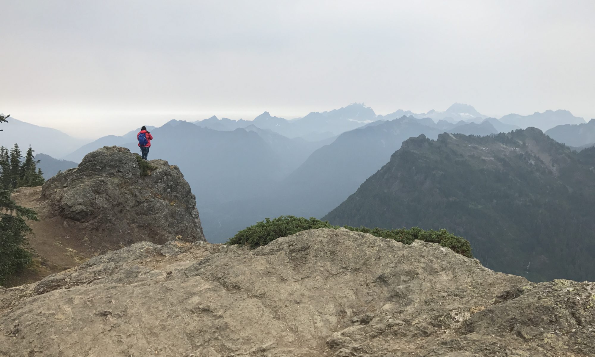
The view at the top was very beautiful, and well worth it. According to the signs, the railroad used to go around this rocky point, slowing to 5 mph.

iron goat trail hike Washington railroad tunnel
View from Windy Point.

They eventually built a tunnel to make the train’s travel through here faster. The tunnel was also interesting to see, although they advised against going through it.

These tunnels have not been maintained in almost 100 years and could collapse at any time. Therefore, nobody should be traveling through or climbing on the tunnel or snowsheds.

There is a pit toilet at Windy Point, although your only privacy comes in the form of Mother Nature’s screen of trees and brush. Nice view from the seat, though!

iron goat trail hike Washington railroad tunnel
Pit toilet at Windy Point.

Tunnels and Snow Sheds along the Iron Goat Trail

Past Windy Point, the trail continues along the outside of the tunnel. I passed two women and their dog along this narrow walkway!

iron goat trail hike Washington railroad tunnel

The East entrance to the tunnel is here. You can go inside the entrance of the tunnel, but they advise against continuing any further.

iron goat trail hike Washington railroad tunnel
Entrance of the eastern end of the old railroad tunnel.
iron goat trail hike Washington railroad tunnel
Informational placard that explains the history of this tunnel.

I think the giant wall in this forest looks vaguely dystopian, reminding me of the Hunger Games or the Maze Runner. It’s a bit surreal to be deep in a peaceful section of the woods, with a man-made structural looming alongside the trail.

iron goat trail hike Washington railroad tunnel

I didn’t want to hike too far, so I turned around and walked back to the western end of the tunnel. This side was the same in that you could only walk into the tunnel entrance.

Interestingly, this side of the tunnel had sport climbing anchors fixed into the concrete. The anchors go all the way around the arch of the tunnel!

iron goat trail hike Washington railroad tunnel
You can see the sport anchors along the edge of the tunnel!

There were also anchors on the wall just outside the tunnel. I’m not sure how popular climbing is here, but it’s a pretty unique place to do it.

After exploring for a bit and taking pictures, I took the trail back down to the parking lot.

Unfortunately, that’s where I got caught in the awful traffic that I mentioned in my report of the Beckler Peak hike.

Overall Thoughts

I definitely would come back to this trail and hike the entire length! It’s very unique and captures an interesting time in history.

The other benefit of this path is that since it’s on an old railroad bed, the trail is very level. The only steep sections are where the lower path connects to the upper one.

It’s also not as crowded as many of the other hikes in this area. It makes for a great stop if you’re going to or from Leavenworth and the Seattle area.

iron goat trail hike Washington railroad tunnel


Beckler Peak Hike

Beckler Peak is a great combination of a relatively easy ascent with fantastic views.

Beckler Peak hike hiking trail mountain

I say relatively easy because compared to other trails to summits nearby, it’s a much gentler slope. That doesn’t mean it’s a walk in the park.

The stats:

7.5 miles round-trip

2300 ft elevation gain

Getting to the Beckler Peak Trailhead

This hike is located along Highway 2, on the way to Leavenworth, Washington. There are quite a few beautiful trails in this area.

Highway 2 is a beautiful, scenic route through the Cascade Mountains. This is the road that leads from the Seattle area to Leavenworth – a Bavarian themed town popular with vacationers.

Washington Trail Association has fantastic descriptions and directions to so many trails in Washington state. I never would have found this hike without getting directions from them!

The turnoff to the forest road that leads to this trailhead is very easy to miss. I used Google maps, which gave directions right up to the trailhead. That gave me a heads up for when to turn.

FR 6066 is the name of the gravel road that you need to take. After almost 2 miles, take the right fork for another 6 miles to the trailhead.

The gravel road has some potholes but is in decent shape, and the drive is doable in a two-wheel drive car.

The trailhead has a pit toilet, which is pretty convenient. This parking lot was not very crowded, even at 9:30 AM on a Sunday afternoon.

Beckler Peak hike hiking trail mountain
Pit toilet at the trailhead to Beckler Peak.
Beckler Peak hike hiking trail mountain
There were still spots open at 9:30 AM on a weekend!

Starting the hike up to Beckler Peak

The trail overall is maintained very well. It’s very obvious where to follow the trail for the entire length, so getting lost shouldn’t be a concern.

The trail starts at a relatively level grade through a forest with tall grass. You will cross a couple of small streams, with one that has eroded the trail a bit.

Beckler Peak hike hiking trail mountain
This section of the trail is slightly washed out, but easily passable.

Then you continue through an old growth forest, and the trail starts to switchback up the mountain. One of my favorite parts of Washington is the abundance of beautiful forests with huge evergreen trees.

The bugs were pretty annoying for me on the way up, but they were better on the way down for some reason. I only got a couple of mosquito bites, so it was mostly flies.

I passed a few people on the way up. This trail is popular enough that you will see plenty of people, but not overwhelmingly so.

There are a few peekaboo views of the surrounding mountains on the upward climb. One thing I didn’t like as much about this trail was the lack of views until the very top.

Beckler Peak hike hiking trail mountain
Stone steps leading to the top.

The views at the top reward you for a tough climb!

There were quite a few people at the peak. The top has a rocky outcrop that everyone was lounging on to enjoy the view.

Beckler Peak hike hiking trail mountain
Everyone admiring the view, not much room up here!

It’s a cool place to hang out, but there’s not much room at the top. And no, that’s not a bad cliche!

The summit area does have a few other spots with beautiful views of the surrounding mountains.

Beckler Peak hike hiking trail mountain
View from the main peak.
Beckler Peak hike hiking trail mountain
View from another part of the peak area.

One of the best parts of a gentler climb is that the way down isn’t as punishing on your knees. I jogged down part of the way just to get back quicker.

Overal thoughts

The pros of this hike include the easy accessibility, the doable climb, and the fantastic views at the top. The drawback is the lack of views until the very top, and the limited space at the peak.

To be honest, I preferred some of the tougher hikes in this area that afford much more dramatic and sweeping views.

Beckler Peak hike hiking trail mountain
I love the sweeping views of evergreen trees!

Mt. Dickerman, Granite Peak, and Mt Pilchuck were much more spectacular. But those first two trails were also much more difficult climbs, with at least 1500 ft extra gain.

This trail is accessible and easy for dogs as wells, and I saw one group with a dog at the summit.

The other drawback to hiking along Highway 2 is the insane traffic on the way back west on Sunday afternoons. Leavenworth is a popular weekend getaway, so I suspect that is the reason.

I also saw many people out swimming and enjoying the Skykomish river. I would love to go on a rafting trip here someday!

Overall, I recommend this hike if you want amazing views with a decent, but not leg-crushing, climb.

Beckler Peak hike hiking trail mountain