Hiking Oyster Dome

I normally love hikes that are very steep uphill and lead to a beautiful view, but this one was especially brutal for some reason. I think that maybe running 6 miles (farthest I’ve gone in a long time) followed by a very steep 5+ mile round trip hike the next day was just too much for my body. It was definitely a fantastic hike but my legs were not happy with me by the end. I wanted to do this hike because it was a long weekend, so I wanted to venture a little further away from home. However I was also aware of the fact that a lot of the mountains inland had gotten snow recently, and I did not have any gear for hiking in snow. Luckily the snow at this trail was all melted the day I went up.

This hike was actually rather difficult to find if you don’t know what you’re looking for. It starts along the Pacific Northwest Trail and the trailhead is on Chuckanut Drive. There is no parking lot, just room for parking on the shoulder. I passed by it at first and had to turn around and come back. I also had no service out here which led to my husband being a bit worried about me for a while! Anyways it’s a very unassuming trailhead and begins by switchbacking up a very steep hill.


IMG_3632
I took the red trail up to the green one, then up to Oyster Dome.
IMG_3656
The trail is very well marked

After about a mile, there’s a nice view with a bench. Rain was threatening all morning but luckily it stayed mostly dry.

IMG_3646
They’ve put a bench here at the first view point.
IMG_3665
Lots of little stream crossings!

The trail continued uphill most of the way. At one point it becomes very steep and there was some trail maintenance halfway done to turn it into switchbacks. This was the only time I got confused because I wasn’t sure if the switchbacks led to a different trail at first. There were a couple other places where the trail split into two paths but would converge not long after. There was also one larger stream that you have to cross and I ended up balancing on some small logs that spanned the water. Even without the views, I love the forests here in the Pacific Northwest; the trees are enormous and the ground is so spongy with pine needles! Finally I got to the top!

IMG_3675
Walking up to the Oyster Dome view!
IMG_3677
The view at Oyster Dome!

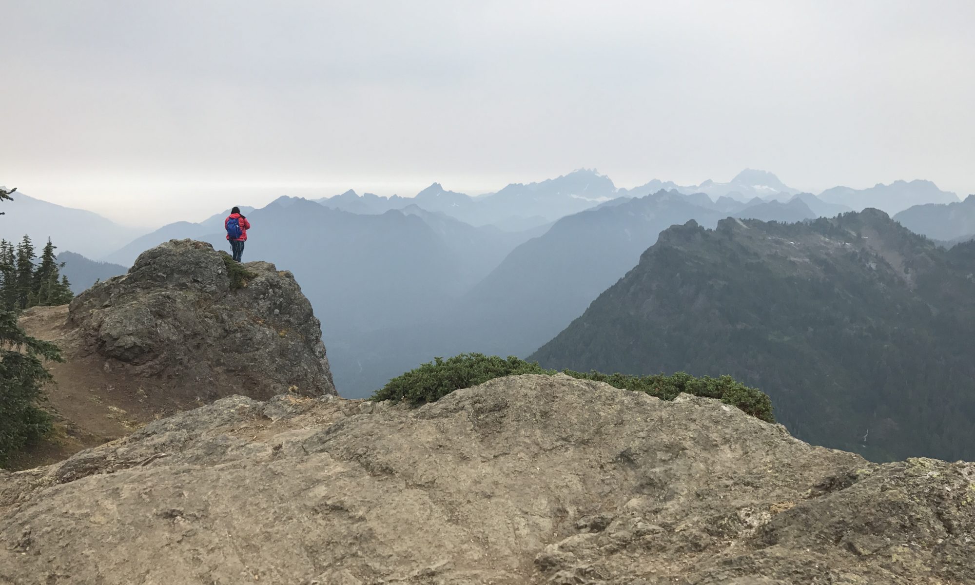
The view was very pretty. I could see Anacortes across the water. It was too cold and windy for me to stay long, however, so I headed back down after taking some pictures. Sometimes I feel like a long downhill section is worse than uphill because it’s so much more pounding on your legs! Eventually I got back down and got some tasty Chipotle in Burlington! Overall a fantastic hike and highly recommended.

Hiking in Deception Pass (Goose Rock)

Deception Pass bridge connecting Fidalgo Island to Whidbey Island

My mom and I were in Oak Harbor for a few days so we decided to do a hike nearby. I’m going to be moving there soon but I don’t know when she’ll be able to visit again, so I wanted her to see some of the beautiful scenery in the area. It’s December, so conditions are generally cold, wet, and overcast. The sun also sets around 4:00 PM so there isn’t much daylight to do hiking in. We went to Deception Pass State Park because it was close by and because I knew there had to be some great views. The only drawback is that there is a fee to hike in the park and they will tow your car if you don’t have a pass displayed. I bought a yearlong pass for $30 which will be well worth it to me.

Hiking uphill through the forest

We parked at the parking lot on the Whidbey Island side of the bridge and began our hike by walking down the stairs that go underneath the bridge. We took the Goose Rock perimeter trail to the summit trail, which took us to the top of Goose Rock. Then we took the other summit trail down the other side of Goose Rock and the perimeter trail took us back to where we began. Here’s a link to the official park map.

The top of Goose Rock

Luckily for us it wasn’t really raining, it was just very overcast and wet. This was a very pretty hike and definitely a departure from hiking in the Southeast US. The forest is very dense and green, and the water by the bridge is also a very pretty green color. My mom wasn’t very impressed with the wet, cold, and dark nature of the Pacific Northwest in winter but I think this hike and the scenery made her feel better about it. And next time she’ll probably visit in the summer!

Looking down into Cornet Bay
Private homes on Ben Ure Island

There is quite a bit of elevation change especially hiking down from Goose Rock. Once you’re back on the perimeter trail it’s better. As you hike close to the shoreline you can see the bay and the islands nearby. We watched someone drive their boat up to Ben Ure Island, where there are some private homes, and they put their stuff in wheelbarrow to take up the dock to their house. Seems an interesting way to live. After arriving back at the bridge and the parking lot, we wanted to walk along the bridge to where it crosses the island in the middle. There are some great views from here and another parking lot. It’s hard to believe that I’m actually going to live here soon! I plan to go on many more great hikes as often as I can!

Hiking the Pinhoti Trail in Talladega National Forest

IMG_2976

Over the long weekend of Columbus day my husband and I did a short overnight hiking trip on the Pinhoti trail. I had pretty low expectations because I assume that all hiking south of Tennessee has lackluster scenery, but fortunately I was proven very wrong!

The Pinhoti trail is 339 miles long and basically connects the southern reaches of the Appalachian Mountains to the rest of the Appalachian Trail. The section we hiked was right next to Cheaha state park. I was super excited because it’s been years since I’ve been backpacking and I’ve wanted to do this for such a long time, but our work schedules just hadn’t allowed us until now! It was a last minute trip but this is such an easy hike that planning ahead isn’t really necessary. We stopped at the camp store at Cheaha National Park before hiking to use the bathroom and try to buy a map, but they didn’t have any in stock. So I took a picture of the map so I’d at least have it on my phone and surprisingly it worked out fine.

IMG_2928
This is the map we used on my phone! We parked at the red TH, took the pink (Pinhoti) trail out to a connector trail and came back up the yellow (cave creek) trail.

Then we parked at the trailhead to the Pinhoti trail. The parking lot was pretty full but out on the trail we only passed a few people. At the entrance they’ve built a pretty cool archway.

IMG_2929

Not long after starting we came to some very impressive views! There was even a really nice campsite next to one of the outlooks. The trail is mostly climbing up at this point but it didn’t seem too strenuous to us.

IMG_2950

We started hiking around 3:00 or 4:00 PM so after a couple of miles we began looking for a good place to camp. We passed quite a few large campsites with fire pits both on the way in and on the way out, so if you ever decide to do this hike don’t worry about finding one! However, the best sites are near McDill Point, where I took the first photo, and on a weekend those get taken early. We ended up camping next to a plane crash, which was kind of cool but also kind of creepy. We tried to look online for information about who crashed and when, but it must have been so long ago that there are no news articles or records online.

IMG_2973
Our campsite, with a campfire in the middle of a crashed plane!

We had fantastic weather the entire time, but it had rained recently so all the wood in the area was damp. However, with our fantastic fire-creating skills (aka lots of tissues for kindling) we had a blazing fire going in no time! We went to bed really early because that’s just what you do when you’re camping. Mainly because after it gets dark there’s nothing else to do. That meant that we also woke up early and we had everything all packed up by 7:00 AM. We had hiked about 3 miles the day before, so we had about 4.5 miles to go to get back to the trailhead. I was very surprised at how easy this was for both of us. Usually hiking with a full pack makes it much more difficult, although we didn’t have any cooking gear so our packs were probably only 25-30 lbs. I think this was a great route for a beginner (it was my husband’s first backpacking trip!) but next time I’d like to do something more challenging.